Saturday, May 12, 2007

China | Gansu Province | Mazong Mountains | Abominable Snowmen

As I mentioned in an earlier post about Jiayuguan I made an Attempt to Visit the Mazong Mountains in northwest Gansu Province. The word mazong, I pointed out, is now translated in most tourism-related ephemera as “horse’s mane,” perhaps a reference to the black appearance of the mountains when seen from distance. Owen Lattimore, who traveled along the northern flank of the mountains with a camel caravan in 1926, maintained however that mazong meant “horse’s hoof-print.”

Having grown up in China Lattimore spoke Chinese like a native, but in 1926 he did not know any Mongolian. In a later 1975 edition of The Desert Road to Turkestan, by which time he had became quite fluent in Mongolian, he elaborated on a new theory about the meaning of the word mazong. Lattimore:
Ma-tsung Shan (mazong in Pinyin) . . . is explained on p. 245 as the “horse hoof-print hills.” This was how the name was explained to me by the caravan men. It was only many years later that I divined the true derivation and meaning of this name. It is from the Mongol Metsin Uul, “Ape Mountains” . . . In other words, what we have here is an extension . . . of the folklore world of the Abominable Snowman of Asia.
The more familiar Mongolian word for Abominable Snowman-like creatures is almas. There is, however, the word мич(mich), which means ape. Used to describe a mountain this word would be spelled мичин (michin), thus Мичин Уул, or Ape Mountains. It is possible then that the Mongolian michin became corrupted in Chinese as Ma-tsung and now in Pinyin style as Mazong? Lattimore would seem to to think so.

However, as far back as the Ming Dynasty, founded in 1368, these mountains were called the Ma Tsung (Mazong) Shan, as pointed out in the Ming Shi, or “History of the Ming Dynasty.” E. Bretschneider, who in his Mediaeval Researches From Eastern Asiatic Sources (London, 1887) translates sections of the Ming Shi, also maintains, like most current commentators, that Ma-tsung means “horse’s mane.” It is possible that the Chinese word was corrupted from the Mongolian as far back as the fourteenth century?

In any case, there were indeed many legends of wild hairy apeman living in these mountains. Are the mountains known as the Mazong Shan actually the Ape Mountains, and thus perhaps one of the abodes of the legendary almas, the Mongolian version of the Abominable Snowman? If so, it would only add to the mystery of these mountains, now inaccessible to foreigners.

For an vastly entertaining tale of the Abominable Snowman of Tibet who steals the Crown of Genghis Khan from Scrooge “The World’s Richest Duck” McDuck only to have it retrieved by Scrooge with the assistance of Donald Duck and his three nephews see “The Lost Crown of Genghis Khan“ in the Greatest DuckTales, Volume 1.
I first read this Scrooge McDuck tale when I was seven years old, at which point I vowed I would someday visit both Tibet, putative home of the Abominable Snowman, and Mongolia, the home of Genghis (Chingis) Khan. At that time Tibet and Mongolia were among the most difficult places in the world for an American to visit, but even then I was confident that in the end I would persevere. I am now happy to say I have been able to fulfill both of these vows.

Monday, May 7, 2007

Mongolia | Bayankhongor Aimag | Amarbuyant Khiid

Amarbuyant Khiid
Amarbuyant is a Gelug monastery located on the high desert steppe north of the Gov-Altai Mountains in Bayankhongor Aimag. Monks now in residence say that the monastery was founded in the 1790s. Originally there were forty monks, and from the very beginning they were famous for their unzad (chanting) in a particularly forceful style. The monks of Amarbuyant eventually became known as the “Beautiful Voiced.” Other than this, little is known about the history of the monastery. It does not appear, for example, in the Mongol Hytag Dakh Tüükh Coyolyn Dursgal (Historical and Cultural Monuments in the Territory of Mongolia), nor does there seem to be much other literature in Mongolian about it.
Another view of Amarbuyant Khiid
The monastery was at one time well-known as the junction of two important caravan routes; the east-west Great Mongolian Road from Hohhot in Inner Mongolia with branches leading to Khovd and Uliastai in Mongolia and Qitai and Urumqi in Xinjiang Province, China; and the north-south route from here to Suzhou (now Jianguan, in Gansu Province of China), across the Black Gobi and the Mazong Mountains. The monastery lost much of its important as a caravan crossroads after the communists closed the Mongolian-Chinese border in the mid 1920 and halted much of the caravan traffic to Xinjiang.

The monastery is also remembered for the visit of the 13th Dalai Lama here in 1904. The Dalai Lama had fled Tibet after the invasion of the Younghusband Expedition. His exact route after leaving the Tibetan Plateau is unclear, but apparently at some point his party picked up the Suzhou–Amarbuyant route across the forbidding Black Gobi. Locals now claim he used this remote and difficult route to avoid the attentions of the Chinese. After crossing the Mongolian border his party, said to number about one hundred people—monks in the Dalai Lama’s entourage, Tibetan governments officials, bodyguards, camel men, cooks, etc.—camped at Shar Khuls Oasis. Word had already reached Amarbuyant of the Dalai Lama’s approach and a party of monks and notable local herdsmen was sent to meet him at Shar Khuls.

The head of the delegation, and also reputed to be the best chanter, was a man named Gendensüren. His grandson Tserendash, who was five at the time, went along with the delegation to Shar Khuls. Tserendash lived until the late 1980s and was the source of much of the information about the Dalai Lama’s sojourn through Bayankhongor. He became famous in Bayankhongor for his eccentricity and stubbornness. This latter trait earned him the nickname of Zörüüd (stubborn). Accompanied by the delegation of chanters and local dignitaries the Dalai Lama and his party made their way north to Amarbuyant. The trip took six long days by camel. All day long while riding their camels the Amarbuyant monks chanted in their famous style. Later, when the Dalai Lama was in Örgöö, he heard many chanters and was asked what he thought of them. He said they were good, but could not match the “Beautiful Voiced” chanters of Amarbuyant. At least this is what local monks now claim. This story may of course be apocryphal.

Meanwhile, the monks at Amarbuyant were preparing for his arrival. Starting two and a half miles south of the monastery, at a place now marked by two ovoos, a pathway was smoothed out for the Dalai Lama’s approach by removing all the large rocks and throwing them to one side. This pathway, with the piles of rocks on either side, can still be seen today. The edges of the pathway was lined with “carpets,” as the monks now describe them, of red, green, yellow, blue, and white Buddhist designs made from powdered minerals found in the surrounding hills (samples of these minerals can now be seen in the small but well-appointed museum in the nearby sum center of Shinjinst).
The beginning of the smoothed path for the Dalai is marked by the two small ovoos shown here.
About 1.8 miles south of the monastery, along the pathway, an assembly area measuring about 150 feet by 200 feet was created by leveling and smoothing the ground. This area, outlined with stones, can also still be seen today. On the northern side of the assembly area is a smaller area outlined with stones where the Dalai Lama sat. The Amarbuyant monks sat on either side of the assembly area and the Dalai Lama proceeded up an aisle in the middle to take his seat.
Roadway smoothed for the Dalai Lama
The Dalai Lama reportedly stayed at Amarbuyant ten days, meeting with monks and giving teachings. He also gave instructions for the building of a new Tsogchin Temple. He first picked out the location for the temple, then built a small ovoo on the ridge directly to the south of the monastery. He instructed the monks to build the temple directly facing this ovoo. Thus the ovoo now directly faces Bor Khairkhan Mountain far off to the south across the desert, as was the Dalai Lama’s intention, although the mountain is not visible from the temple itself. The ovoo can still be seen today. Locals say that while It is the custom for people to add rocks to ovoos while circumambulating them out of deference to Dalai no stones have ever been added to this ovoo, nor has it been adorned with khadags or anything else.
Ovoo built by the Dalai Lama to align new Tsogchin Temple with Bor Khairkhan Mountain, just visible in the distance.
The restored Tsogchin Temple
Looking south across the Gobi from the Tsogchin Temple
One of the monks who had accompanied the Dalai Lama the whole way from Lhasa, the enigmatic world-class intriguer Agvan Dorjieff, a Buryat who had once studied at Gandan Monastery in Örgöö (Ulaan Baatar)) and went on to become the Dalai Lama’s tutor, hurried on from Amarbuyant to Örgöö by himself to inform the Russian government via telegraph that the Dalai Lama was now on the territory of Mongolia. At this point the Dalai Lama’s itinerary was unclear, and it was mooted that he might want to continue on to Russia. Dorjieff, a dedicated Shambhalist (it was probably he who introduced Nicholas Roerich and his wife Elena to the Shambhala mythologem) had once hinted that Russia was actually the legendary kingdom of Northern Shambhala and that the Czar of Russia was the King of Shambhala. Thus the Dalai Lama might be interested in visiting Russia and meeting the Czar. As it turned out nothing came of these overtures.

Amarbuyant appears in the travel accounts of George and Nicholas Roerich, Owen Lattimore, and other non-Mongolian travelers as Yum Beise (or Yun Beise) Monastery. On my first visit to Bayankhongor in 1998 I asked dozens of otherwise well-informed people about the whereabouts of Yum Beise Monastery. No one had ever heard of it. I first assumed that it had been totally destroyed by the communists and had now even passed from people’s memory. Then I met a very knowledgeable man who worked as a cashmere buyer, traveling all over the Bayankhongor (he claimed to have met every herder in the entire aimag), and he explained that beise is a title given by the Qing to Mongolian noblemen. Yum Beise was a local nobleman and the monastery was located on his territory; thus foreigners, perhaps due to faulty translations, began incorrectly calling it Yum Beise Monastery. This name was never used by Mongolians.
Stupas behind the Monastery
The Roerich Expedition headed by famous artist Nicholas Roerich and his son the well-known scholar and Tibetan translator George visited Amarbuyant in April of 1927. Oddly enough, even at this early date they were able to drive from Örgöö to Amarbuyant, although not without a great deal of difficulty. The grandly styled Roerich Expedition left Urga on April 13, 1927 in three trucks and two Dodge touring cars and arrived in Yum-Beise, as they called it, about a week later. By then the caravan routes to Hohhot and Xinjiang had been closed by the communists and the monastery had fallen on hard times. Nicholas Roerich was not impressed by what he found: “Yum-Beise is an unpleasant, windy place. The monastery itself is not an inviting one and the lamas are not gracious. Beyond and above the monastery, on the mountain, a tremendous phallus is erected. . . .”

Nor was George Roerich enthusiastic:
The northern wall was occupied by the state throne of the Incarnated Lama of the monastery and several cases containing brass and clay images of crude workmanship . . . We noticed only a few painted banners. A big one hanging on one of the columns displayed a black and white drawing of the mandala or mystic sphere of influence of Shambhala, said to have been presented to the monastery by order of the late Bogdo Gegen. The rest of the banners were painted in bright colors, but of a very inferior design. We searched in vain for the finely executed banners from eastern Tibet and Derge. Most of the brass images in the glass cases either came from eastern Tibet or from Dolon-nor. We were surprised to find such a paucity of really good things. The küren situated on the caravan route to Tibet should possess better examples of Tibetan religious art.
They had planned to continue on by car and truck south across the Gobi, but the monks and caravan men at the monastery warned them that this was impossible. They finally hired a man named Lama Sambu, “well-known guide and caravan leader,” and proceeded south by camel on the caravan route used by the Dalai Lama.

One of several stupas on the ridge north of the the monastery built to protect it from prevailing north winds
In the mid-1930s the monks at Amarbuyant heard rumors that the communists were planning to close their monastery. Some of them fled to China. When the communists finally did come the monks under the age twenty-five were drafted into the army and reportedly many ended up fighting with the Soviet Red Army in Germany. Older, high-ranking monks were executed, reportedly shot while holding their begging bowls in their hands. Most of the temples are destroyed or heavily damaged. Restoration work began in the 1990s. About a dozen monks are now in residence and they are attempted to revive their reputation as the “Beautiful Voiced.”
Ruins of temples destroyed by the communists

Thursday, April 26, 2007

China | Beijing | Silk Street Market | Carpets

From Jiayuguan I took the 8:40 pm sleeper train to Lanzhou, arriving at 7:05 am, caught a bus straight to the airport, which is a good thirty miles out of the city, and jumped on the 11:00 flight back to Beijing. By late afternoon I was in the notorious Silk Street Market on Jianguomen continuing my never-ending quest for the perfect round silk carpet. These are of course much harder to find than the regular rectangular models. I did manage to find a few, however, and also got a chance to look at some heart-stoppingly gorgeous examples of other carpets.
If a sight like this does not make your heart palpitate you better check to see if you have not already assumed room temperature.
Heart palpitating yet?
Half of a nice 600 knot per inch silk carpet
800 knot per inch silk rug
600 knot per inch silk rug
A mouth-wateringly luscious 800 knot-per-inch silk rug
Along the top of this photo is part of a three-foot-wide–ten-foot-long carpet—more properly tapestry, since it is meant to be hung on the wall and not trod on—depicting scenes from the Silk Road. This 1000 knot-per-inch silk carpet goes for 120,000 yuan ($15,256).
A magnificent 60o knot per inch silk carpet depicting various Buddhist iconography. Obviously this carpet-tapestry is also intended to be hung on a wall (see Enlargement). Measuring eight-by-ten feet, it’s a near-antique, 5o years old, and goes for 85,000 yuan ($10,806).
Finally moved on to the round carpets. The Quest has been narrowed down to four choices.
Round 400 knot per inch all silk rug
Half-Silk–Half Wool Round Carpet (see Enlargement)

Sunday, April 22, 2007

China | Gansu Province | Jiayuguan | Lanzhou

Unable to arrange a trip to the Mazong Mountains I booked a berth on the 8:40 pm sleeper train back to Lanzhou. That gave me a free afternoon so I decided to head back to the fort for a more leisurely look around. Arriving at the fort I immediately encountered Ms. Chan in the parking lot. She came bounding over, seemingly overjoyed to see me. Via sign language I indicated that I was going into the fort and would not need a car. She just nodded and smiled.
Ms. Chan
On my earlier trip there had been several hundred visitors to the fort but this was a weekday and the place was nearly deserted. I spend three hours slowly circumnavigating the top of the fortress wall, pausing here and there to daydream about the events which must have taken place here over the last seven centuries.
Inside of fort on a quiet day
When I emerged from the fort in the late afternoon there was Ms. Chan right by the entrance gate. I was going to go back to the hotel, but since she was apparently waiting for me I mentioned in Chinese the name of the so-called Beacon Tower overlooking the Taolai River a couple of miles away. This is one of the standard sights in the area but one I was going to forgo; since Ms. Chan seemed eager however I decided to go have a look. On the way Ms. Chan stopped at a store roadside store and came out with a liter bottle of mineral water for me. When I tried to pay for it she just waved me off.
From the fort the unrestored, pounded earth wall runs due south to the Taolai River
There are several beacon towers in this section, including one right on the cliff overlooking the river.
Taolai River
The day up till now had been warm with a solid dome of cobalt-blue sky overhead. No sooner did we arrive at the river than it very suddenly clouded over and a ferocious wind starting howling out of the north. Then it started snowing, huge snowflakes the size of half dollars driven almost horizontally by the wind. Soon visibility was down to about thirty feet. Ms. Chan laughed uproariously, as if this blizzard in the middle of what had been a warm spring day was the funniest thing she had ever seen in her life. As soon as the snow slowed down a bit we headed back to my hotel. I grabbed my bag and then had Ms. Chan take me to the train station. Despite my protestations she insisted on carrying my bag into the train station and then waited with me until I boarded the train. When the train pulled away she was still on the platform waving. It was a bit of a mystery to me why she was being so solicitous. I am almost tempted to think that she was an emanation of White Tara, the Protectress of Travelers. I even felt a a pang of guilt about not giving her a tip, but I reasoned that Tara would not expect one.

Thursday, April 19, 2007

China | Gansu Province | Ja Lama

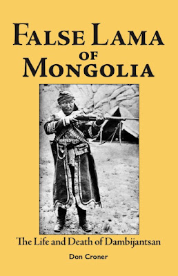
Who was Dambijantsan?

A Buddhist monk; a freedom fighter for Mongolian independence; the descendant of Amursanaa (1723–1757), the Western Mongol who led the last great uprising against the Qing Dynasty of China; the incarnation of Mahakala, the Buddhist god of war; bandit, torturer, murderer, or evil incarnate? During his lifetime no one was sure who he really was, and even today the controversy about his life continues.

Born in what is now the Republic of Kalmykia, part of the Russian Federation, Dambijantsen traveled throughout Tibet, India, and China before arriving in Mongolia in 1890 where he tossed gold coins to bystanders and announced to one and all that he had come to free Mongolia from the yoke of the Qing Dynasty of China. After disappearing almost twenty years he returned to lead the attack on Khovd City, the last Chinese outpost in Mongolia. Honored by the Eighth Bogd Gegeen, the theocratic leader of Mongolia, for his efforts in achieving Mongolian independence, he went on to establish his own mini-state in western Mongolia, which he hoped to use as a base for establishing a Mongol-led Buddhist khanate in Inner Asia. His dictatorial nature and unbridled sadism soon came to the fore and he was finally arrested and imprisoned in Russia. After the Russian Revolution he returned to Mongolia, gathered new followers around him, and established a stronghold at the nexus of old caravan routes in Gansu Province, China. He robbed caravans, grew opium, and once again dreamed of creating a new Mongolian khanate in Inner Asia. Finally the new Bolshevik government in Mongolia, fearful of his rising power, issued orders for his assassination. Dambijantsan died in 1922, but in Mongolia legends persist to this day that his spirit still rides on the wind of the Gobi and continues to haunt his former lairs.


For more on Dambijantsan see False Lama of Mongolia: The Life and Death of Dambijantsan


China | Gansu Province | Jiayuguan | Ming Fort

Jiayuguan Fort is located on a terrace between the Wenshu Mountains on the south and the Heishan (Mountains) on the north, 4.2 miles from the Overhanging Wall.
Wall from the Overhanging Wall to the Fort
The fort was built in 1362 under the command of Ming General Feng Sheng. The craftsman in charge of construction, Yi Kaizhan, ordered all the material needed in advance, and according to legend his planning was so meticulous that when the fort was completed there was only one brick left over. During Ming times the fort marked the westernmost point of Celestial Kingdom, and because many of the various branches of the Silk Road funneled through here the location became known as the “Greatest Pass Under Heaven.”
Jiayuguan FortThe walls of the fort are thirty-five feet high and 3406 feet around the perimeter.
View from instead the Fort
On the eastern side of the fort is the three-storied Guang-hua Men Gate (Gate of Enlightenment). On the western side is the 56-foot-high Rouyuan Men (Gate of Reconciliation), added to the fort in 1506 by General Duanroheng. Those who passed through this gate were leaving China and entering the desolate land of the barbarians. Traders and adventurers who went voluntarily hoped to gain fortune or fame, but for those who went involuntarily passing through the Rouyuan Gate was their worst nightmare.
The Rouyuan Gate
Disgraced officials sent into exile, condemned criminals, fugitives, desperados, and homeless drifters all crossed here into the empty desert beyond. It was the custom for those leaving to write on the walls of the Gate poems expressing their feelings as they left the familiar world of China for the Unknown. Many were the heart-rending tales told here. Also, after passing through the Rouyuan Gate it as a custom for travelers to throw a stone at the western wall of the fort. According to legend, if the stone bounced off the wall the traveler would someday return to China. If the stone hitting the wall also made an echo one’s affair would prosper. If the stone simply fell noiselessly to the ground after hitting the wall one was destined to die in the wilderness beyond.
From the top of the Rouyuan Gate, beyond the much lower Wenshu Mountains in the foreground, can be seen the glacier-capped 18,000 foot-plus Qilian Mountains. To the north, beyond the Heishan, are the black ridges of the Mazong (Horse’s Mane) Mountains, with peaks up to 7500 feet-high.
Another view of the Great Wall from the Fort to the Wenshu Mountain in the near distance.

Wednesday, April 18, 2007

China | Gansu Province | Jiayuguan | Great Wall

From Beijing I took one of the morning planes to Lanzhou, on the Yellow River in eastern Gansu, 704 miles to the west, and then caught the afternoon puddle-jumper on to Jiayuguan, 369 miles still farther west.
Lanzhou, on the Yellow River
In Jiayuguan I wanted to check out the possibility of making a trip to the Mazong (Horse’s Mane) Mountains to the north and Gobi Desert beyond.

The bus from the airport was not running—there were only about thirty people on the small plane and most of them seemed to be locals who were met at the airport by acquaintances. I had to take a cab for the six-mile trip into town. The cab driver was a woman in her mid-twenties. She delivered me to the Jiayuguan Hotel on the main city square and insisted on carrying my bag inside. I had read that the Jiayuguan Hotel was a dump and was going to stay there only because it was conveniently located. The accounts must have been written before a recent upgrade. The place now is quite up-scale and all the receptionists and even some of the waitresses in the restaurant speak English. The listed price reflected the upgrade—400 yuan for a standard room; more than the venerable Yong An, where I stay in Beijing—but this price was quickly lowered to 200 yuan when I showed signs of heading for the door. Mid-April is the off-season in Jiayuguan. All the while the cab driver was hovering by my elbow. Speaking through one of the receptionists she then offered to take me the next morning to the two most famous local sights—the westernmost extension of the Great Wall of China and the Jiayuguan Fort, on the western edge of town. A price was arrived at and we agreed to meet at nine the next morning.

There was some kind of settlement here in this wide corridor between the Qilian Mountains to the north and the Mazong Mountains to the north since at least Han times some two thousand years ago. More than a thousand tombs dating from the Wei (220-265) and Western Jin ((265-316) dynasties are scattered around the surrounding desert. During the Ming Dynasty the fort here marked the western limits of the Chinese Empire. The Great Wall, starting far to the east at Shanhaiguan on the Bohai Gulf, ended here, and in 1372 a fort was built to guard the border. The nearby town become knowns as “Jiayuguan,” which means “Barrier of the Pleasant Valley.” The city now has a population of some 115,000. Cement and fertilizer factories dominate the town, and iron ore and coking coal are mined in the nearby mountains. Although nowhere near as famous a tourist attraction as Dunhuang, some five hours by bus to the south, a fair amount of tourists stop by to see the Great Wall, the fort, and a smattering of other local sights. All serous Silk Roadies make an obligatory stop here because of its importance as a way-station on the Silk Road.

The day I arrived it had been very overcast and I was not able to be see much of the surrounding area either on the plane’s approach or on the drive into town. The next morning I was a bit startled when I drew back the curtains and beheld the glacier-capped 18,000 foot-plus Qilian Mountains dominating the entire southern horizon.
Qilian Mountains from Downtown Jaiyuguan
The town itself is at an elevation of 5385 feet. In the foreground to the south were in the much lower buckskin colored Wenshu Mountains. It was these mountains to the south and the Heishan to the immediate north and the Mazong beyond that funneled many of the various caravan routes of the Silk Road through this area. That is why during the Ming Dynasty this place was called “The Greatest Pass Under Heaven.”

The driver was right on time the next morning. Her name is Chan. She is in her late twenties I would say, very thin, with a finely chiseled face. I quickly discovered she did not speak a single word of English. For someone who works with the public she seemed intensely shy—or maybe she was just shy around foreigners. She would glance at me out of the corner of her eyes for a microsecond and than intently stare straight ahead, as if she had seen something she really shouldn't have. Our first stop is the so-called Overhanging Wall section of the Great Wall, 6.2 miles from the hotel on the city square. From the fort, 4.2 miles away, the Wall runs across flat desert and ends at the top of a high hill.
The Overhanging Wall
Beyond here the rugged ridges of the Heishan form a natural barrier. A wall was built here probably as early as the Han Dynasty some 2000 years ago but the current version dates from the Ming Dynasty.
The Overhanging Wall
After the fall of Mongolian Yuan Dynasty in 1368 a Ming army led by General Feng Sheng drove the last of the Mongol armies from the region. The existing wall was upgraded and new sections built in an attempt to prevent any further Mongol incursions. The pounded earth wall from the fort to the Overhanging Wall appears to be more-or-less the original version, but the brick section climbing up the spine of the mountain appears to have undergone extensive restoration.
The Overhanging Wall
Nearby is a newly installed suite of granite statues depicting various travelers, pilgrims, and generals who have filed through Jiayuguan over the ages.
Among the more notable is Lao Tzu, the founder of Taoism, who some sources claim made the first recorded trip through Jiayuguan in the fifth century BC. Lao Tzu was of course the author of record of the Dao De Qing, the seminal text of Taoism. Discouraged that so few people were willing to follow his teachings of The Way he mounted his black buffalo and rode westward. Here at Jiayuguan he left China proper and disappeared into the wilderness beyond and hence into legend. That he was supposedly between 160 and 200 years old when he made the trip brings the historicity of this whole account into question.
Lao Tzu
There is no doubt about the historicity of Xuanzang, the peripatetic pilgrim who passed this way around 630 on his way from Xian in Shaanxi Province to India. I have visited numerous places in Xuanzang’s itinerary, including Lanzhou in eastern Gansu Province; Turpan and Khotan in Xinjiang, Bodhgaya, site of the Buddha’s Enlightenment, nearby Vulture's Peak, where the Buddha taught, and the great Buddhist university of Nalanda, all in India; the Big Goose Pagoda in Xian where the Buddhist texts he brought back from India were stored, and his tomb at Xingjiao Temple near Xian.
Peripatetic Pilgrim Xuanzang with his panier of sutras brought back from India
Near the statue complex is Jiayuguan’s only Buddhist temple, which has recently been restored.
Temple
Nearby is another section of wall which is being restored and is not open to the public. When I expressed a desire to see it Ms. Chan took a dirt road to the base of the mountain and then led me up an extremely steep narrow foot path which ended at an opening in the wall where the workmen gained access. I had to admire her pluckiness. She was wearing street shoes and had to climb several of the steep sections of the trail on her hands and knees.
View of the Overhanging Wall, with Buddhist Temple at bottom left
We climbed onto the top of the wall, where several workmen were repairing the brick steps, and proceeded upwards. Ms. Chan really seemed to be enjoying herself. She whooped and hollered as we climbed higher and new vistas were presented to us.
The charming Ms. Chan taking a breather
I got the impression that she had been on the lower part of the wall where the workman were but had never before climbed to the top.
Climbing to the to Beacon Tower
From the tower we were presented with a sweeping view of the mountains to the north and south and the corridor between them which made this place so strategically important.
The Greatest Pass Under Heaven

Thursday, April 12, 2007

China | Beijing | White Pagoda

Spent the morning at Beihai (Northern Sea) Park in northcentral Beijing. The park is centered around a made-made lake created by Khubilai Khan, grandson of Chingis Khan and founder of the Mongolian Yuan Dynasty. Near the middle of the lake is man-made Qiong Island also reportedly created by Khubilai. The island is surmounted by a high hill, and on the top of the hill is the 118-foot-high White Pagoda. The White Pagoda was built in 1651 to commemorate a visit to Beijing by the Fifth Dalai Lama. (The Yellow Temple, where Zanabazar, First Bogd Gegeen of Mongolia, died, was built as a residence for the Dalai Lama during his stay in Beijing.) The pagoda was damaged during earthquakes in 1679, 1730, and 1976. It has just recently been refurbished in anticipation of the 2008 Olympics.
The causeway to Qiong Island with the White Pagoda on the horizonAnother approach to the White Pagoda
Climbing the steps to the White Pagoda
The White Pagoda with the Shan Yin Dian to the left.
The Shan Yin Dian (Hall of Beneficient Causation) was built in 1751 by Emperor Qian Long. On the side of the hall are 455 glazed tiles each containing a small Buddha in relief.
455 Buddhas of the Shan Yin Dian
Buddhas of the Shan Yin Dian
Statue of Yamataka inside the Shan Yin Dian
Just below the pagoda is the Yong An temple complex. In one of the temples are statues of the Dalai Lama, Panchen Lama, and Tsongkhapa, founder of the Gelug sect of Tibetan Buddhism.
Statue of Amitayus in the Yong An temple complex
Tantric Diety and consort in the Yong An temple complex